
-

Conceptualization and Application of the Alaska Thermokarst Model
W. Robert Bolton, Mark Lara, Helene Genet, Vladimir Romanovsky, and A. David McGuire
Thermokarst topography forms whenever ice-rich permafrost thaws and the ground subsides due to the volume loss when ground ice transitions to water. The Alaska Thermokarst Model (ATM) is a large- scale, state-and-transition model designed to simulate transitions between landscape units affected by thermokarst disturbance. The ATM uses a frame-based methodology to track transitions and proportion of cohorts within a 1-km2 grid cell. In the arctic tundra environment, the ATM tracks thermokarst-related transitions among wetland tundra, graminoid tundra, shrub tundra, and thermokarst lakes. In the boreal forest environment, the ATM tracks transitions among forested permafrost plateau, thermokarst lakes, collapse scar fens and bogs. The spatial distribution of cohorts [landcover] is required to initialize and run the ATM. The initial landcover distribution is based upon analysis of compiled remote sensing data sets (SPOT-5, Inferometric Synthetic Aperture Radar, and LandSat8 OLI) at 30-m resolution. Remote sensing analysis and field measurements from previous and ongoing studies are used to determine the ice-content of the soil, the drainage efficiency (or the ability of the landscape to store or transport water), the cumulative probability of thermokarst initiation, distance from rivers, lake dynamics (increasing, decreasing, or stable), and other factors which help determine landscape transition rates. Tundra types are allowed to transition from one type to another (for example, wetland tundra to graminoid tundra) under favorable climatic conditions.
-

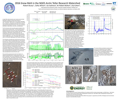
2016 Snow Melt in the NGEE-Arctic Teller Research Watershed
Robert Busey, Cathy Wilson, Go Iwahana, W. Robert Bolton, and Lily Cohen
In April 2016, daily transects were made across the Teller Road Basin to begin the several year process of characterizing the largest event in the northern hydrologic year: snow melt. This year was an experiment to see how much could be accomplished (a full suite of time intensive measurements) during this interval.
-

Education, Resilience, and Scenarios: Creating Capacity for Community- Based Observations through Youth Engagement
Douglas Cost and A. L. Lovecraft
Education and learning possess powerful potential in affecting future resilience and community-based monitoring. This research focuses on examining the connections and feedbacks between social-environmental systems (SESs), resilience, and compulsory education. We suggest scenarios development as a way to link local-scale interest in change to education and monitoring of key variables for resilience. SESs have been problematized as frequently having a poor fit between environmental change and policy solutions. This has led to discussion and debate over the role of schools in addressing local knowledge, environmental changes, and community priorities. In Alaska and other Arctic countries, the role of public schools in improving this fit has been largely overlooked. This research explains that as extensions of governments, public schools offer an opportunity to create better linkages between societies and environments through governance. Secondarily, at the individual level, education is a vital component of resilience, but such education must embrace multiple perspectives in its curriculum in order to honor and access the diversity offered by local, traditional ecological knowledge and Western methods. Scenarios are inherently transdisciplinary processes that integrate different knowledge perspectives as participants consider what matters the most and what is most uncertain in the long-range future. We report research results from two linked scenarios projects. The Northern Alaska Scenarios Project (NASP) drew resident expert participants from the North Slope and Northwest Arctic Boroughs and the Arctic Future Makers project (AFM) that completed a scenarios exercise with high school students from across the Northwest Arctic Borough.
-

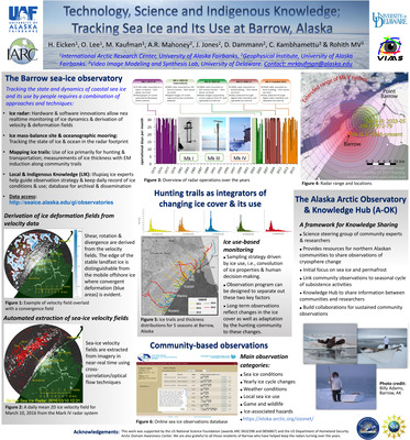
Technology, Science and Indigenous Knowledge; Tracking Sea Ice and Its Use at Barrow, Alaska
H. Eicken, O. Lee, M. Kaufman, A. R. Mahoney, J. Jones, D. Dammann, C. Kambhamettu, and MV Rohith
-
 and Regional Arctic System Model (RASM) by Meibing Jin, Clara Deal, Wieslaw Maslowski, Andrew Roberts, Frants Marina, Osinski Robert, and Anthony Craig")
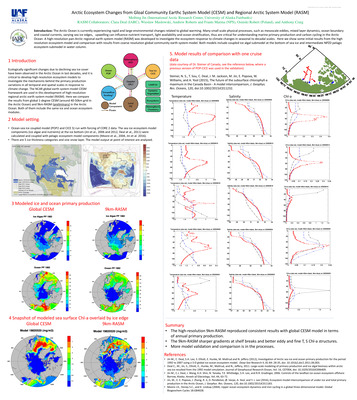
Arctic Ecosystem Changes from Gloal Community Earthc System Model (CESM) and Regional Arctic System Model (RASM)
Meibing Jin, Clara Deal, Wieslaw Maslowski, Andrew Roberts, Frants Marina, Osinski Robert, and Anthony Craig
The Arctic Ocean is currently experiencing rapid and large environmental changes related to global warming. Many small scale physical processes, such as mesoscale eddies, mixed layer dynamics, ocean boundary and coastal currents, varying sea ice edges, upwelling can influence nutrient transport, light availability and ocean stratification, thus are critical for understanding marine primary production and carbon cycling in the Arctic Ocean. A high-resolution pan-Arctic regional earth system model (RASM) was developed to investigate the ecosystem response to climate changes in seasonal to decadal scales. Here we show some initial results from the high resolution ecosystem model and comparison with results from coarse resolution global community earth system model. Both models include coupled ice algal submodel at the bottom of sea ice and intermediate NPZD pelagic ecosystem submodel in water column.
-

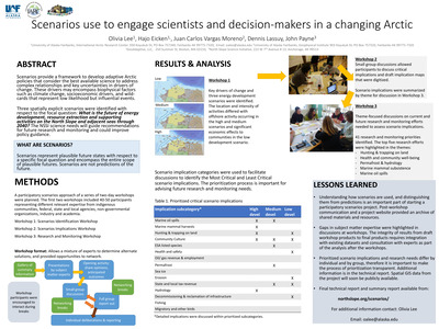
Scenarios use to engage scientists and decision-makers in a changing Arctic
Olivia Lee, Hajo Eicken, Juan Carlos Moreno, Dennis Lassuy, and John Payne
Scenarios provide a framework to develop adaptive Arctic policies that consider the best available science to address complex relationships and key uncertainties in drivers of change. These drivers may encompass biophysical factors such as climate change, socioeconomic drivers, and wild- cards that represent low likelihood but influential events. Three spatially explicit scenarios were identified with respect to the focal question: What is the future of energy development, resource extraction and supporting activities on the North Slope and adjacent seas through 2040? The NSSI science needs will guide recommendations for future research and monitoring and could improve policy guidance.
-

Scenarios to prioritize observing activities on the North Slope, AK
Olivia Lee, Dennis Lassuy, John Payne, Juan Carlos Vargas, and Hajo Eicken
The North Slope of Alaska is experiencing rapid changes in response to interacting climate and socioeconomic drivers. The North Slope Science Initiative (NSSI) is using scenarios as a tool to identify plausible, spatially explicit future states of resource extraction activities on the North Slope and adjacent seas through the year 2040. The objective of the scenarios process is to strategically assess research and monitoring needs on the North Slope. The participatory scenarios process involved stakeholder input (including Federal, State, local, academic, industry and non-profit representatives) to identify key drivers of change related to resource extraction activities on the North Slope. While climate change was identified as a key driver in the biophysical system, economic drivers related to oil and gas development were also important. Expert-reviewed informational materials were developed to help stakeholders obtain baseline knowledge and stimulate discussions about interactions between drivers, knowledge gaps and uncertainties. Map-based scenario products will allow mission-oriented agencies to jointly explore where to prioritize research investments and address risk in a complex, changing environment. Scenarios consider multidecadal timescales. However, tracking of indicator variables derived from scenarios can lead to important insights about the trajectory of the North Slope social-environmental system and inform management decisions to reduce risk on much shorter timescales. The inclusion of stakeholders helps provide a broad spectrum of expert viewpoints necessary for considering the range of plausible scenarios.
-

Scenarios in Social-Ecological Systems: Co-Producing Futures in Arctic Alaska
A. L. Lovecraft and H. Eicken
Scenarios are used to think ahead in rapidly changing, complex, and competitive environments, and make crucial decisions in absence of complete information about the future. Currently, at many regional scales of governance, there is a growing need for legitimate tools that enable the actors (e.g., governments, corporations, organized interests) at local-scales to address pressing concerns in the midst of uncertainty. This is particularly true of areas experiencing rapidly changing environments (e.g., drought, floods, diminishing sea ice, erosion) and complex social problems (e.g., remote communities, resource extraction, threatened cultures). Scenario exercises produce neither forecasts of what is to come nor are they visions of what participants would like to happen. Rather, they produce pertinent evidence-based information related to questions of “what would happen if...” and thus provide the possibility of strategic decision- making to plan research that promotes community resilience.
-

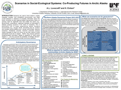
Integrating Culturally-Responsive, Locally Relevant Learning and Citizen Science Through Arctic and Earth SIGNs
Elena B. Sparrow and Katie V. Spellman
To build the capacity to navigate the challenges associated with a changing climate, learning in Arctic communities must not only increase knowledge, but also generate new knowledge as the rapid changes occur. Citizen science, the process whereby citizens (including K-12 students) are involved in science as researchers, presents a possible mechanism to meet this need. However, hypothesis-driven models of citizen science have been criticized for a disconnect between scientific agendas and the priorities and needs of diverse communities. The new education and research program at the University of Alaska Fairbanks, entitled Arctic and Earth SIGNs (STEM integrating GLOBE and NASA), provides new opportunities for K-12 students, pre- and in-service teachers and lifelong learners from diverse communities to engage in citizen science learning.
-

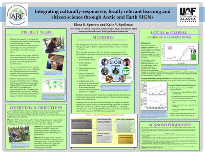
Arctic Storm Activities in Ensemble Simulations by the HIRHAM-NAOISM Regional Coupled Climate Model
Yang Yang, Xiangdong Zhang, and Annette Rinke
Arctic storm activities have shown intensification during recent decades, which may have contributed to or caused extreme climate events. We examined Arctic storm activities in 10 ensemble simulations by using the Arctic regional coupled climate model HIRHAM-NAOSIM. Storm identification and tracking algorithm (Zhanget al., 2004) were employed to derive intensity, location and duration of each storm. Arctic regional storm climatology and variability were constructed and compared with the same statistics derived from the ERA-interim reanalysis data.
-
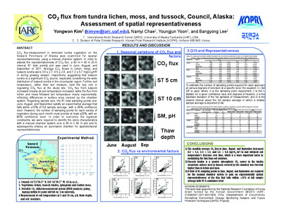
: Data Verification and Climate Analysis by Xiangdong Zhang, Jing Zhang, Jeremy Krieger, Martha Shulski, Fushong Liu, Steve T. Stegall, and Wei Tao")
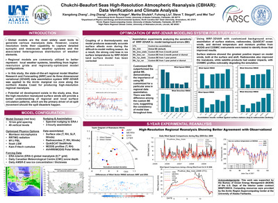
Chukchi-Beaufort Seas High-Resolution Atmospheric Reanalysis (CBHAR): Data Verification and Climate Analysis
Xiangdong Zhang, Jing Zhang, Jeremy Krieger, Martha Shulski, Fushong Liu, Steve T. Stegall, and Wei Tao
Global models are the most widely used tools to generate various reanalysis data. However, coarse resolution limits their capability to capture detailed synoptic and mesoscale weather systems and the associated heterogeneous distribution of weather elements. Regional models are commonly utilized to better represent local weather systems, benefiting from higher- resolution grids and regionally-optimized model configurations. In this study, the state-of-the-art regional model Weather Research and Forecasting (WRF) and its three dimensional variational (3DVAR) data assimilation system WRF-3DVAR was applied to the Arctic marginal ice zone along the northern Alaska Coast for producing high-resolution regional reanalysis. Potential oil development exists in the study area, thus the high-resolution reanalyzed surface winds will provide a better understanding of regional and local surface circulation patterns, which are the primary driver of oil spill movement should the spill disasters happen.
-

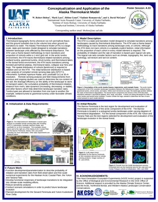
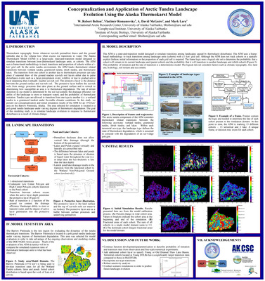
Conceptualization and Application of Arctic Tundra Landscape Evolution Using the Alaska Thermokarst Model
W. Robert Bolton, Vladimir Romanovsky, A. David McGuire, and Mark Lara
Thermokarst topography forms whenever ice-rich permafrost thaws and the ground subsides due to the volume loss when excess ice transitions to water. The Alaska Thermokarst Model (ATM) is a large-scale, state-and-transition model designed to simulate transitions between [non-]thermokarst landscape units, or cohorts. The ATM uses a frame-based methodology to track transitions and proportion of cohorts within a 1- km2 grid cell. In the arctic tundra environment, the ATM tracks thermokarst related transitions between wetland tundra, graminoid tundra, shrub tundra, and thermokarst lakes. The transition from one cohort to another due to thermokarst processes can take place if seasonal thaw of the ground reaches ice-rich soil layers either due to pulse disturbance events such as a large precipitation event, wildfire, or due to gradual active layer deepening that eventually reaches ice-rich soil. The protective layer is the distance between the ground surface and ice-rich soil. The protective layer buffers the ice-rich soils from energy processes that take place at the ground surface and is critical to determining how susceptible an area is to thermokarst degradation. The rate of terrain transition in our model is determined by the soil ice-content, the drainage efficiency (or ability of the landscape to store or transport water), and the probability of thermokarst initiation. Tundra types are allowed to transition from one type to another (i.e. a wetland tundra to a graminoid tundra) under favorable climatic conditions. In this study, we present our conceptualization and initial simulation results of the ATM for an 1792 km2 area on the Barrow Peninsula, Alaska. The area selected for simulation is located in a polygonal tundra landscape under varying degrees of thermokarst degradation. The goal of this modeling study is to simulate landscape evolution in response to thermokarst disturbance as a result of climate change.
-

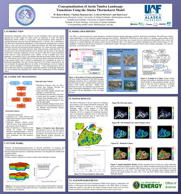
Conceptualization of Arctic Tundra Landscape Transitions Using the Alaska Thermokarst Model
W. Robert Bolton, Vladimir Romanovsky, A. David McGuire, and Mark Lara
Thermokarst topography forms whenever ice-rich permafrost thaws and the ground subsides due to the volume loss when excess ice transitions to water. The Alaska Thermokarst Model (ATM) is a large-scale, state-and-transition model designed to simulate landscape transitions between landscape units, or cohorts, due to thermokarst. The ATM uses a frame-based methodology to track transitions and proportion of cohorts within a 1-km2 grid cell. In the arctic tundra environment, the ATM tracks landscape transitions between non-polygonal ground (meadows), low center polygons, coalescent low center polygons, flat center polygons, high center polygons, ponds and lakes. The transition from one terrestrial landscape type to another can take place if the seasonal ground thaw penetrates underlying ice-rich soil layers either due to pulse disturbance events such as a large precipitation event, wildfire, or due to gradual active layer deepening. The protective layer is the distance between the ground surface and ice-rich soil. The protective layer buffers the ice-rich soils from energy processes that take place at the ground surface and is critical to determining how susceptible an area is to thermokarst degradation. The rate of terrain transition in our model is determined by the soil ice-content, the drainage efficiency (or ability of the landscape to store or transport water), and the probability of thermokarst initiation. Using parameterizations derived from small-scale numerical experiments, functional responses of landscape transitions will be developed and integrated into NGEE-Arctic climate-scale (CLM) modeling efforts.
-
Investigation of retrieved snow depth by microwave remote sensing with in-situ field data
Yongwon Kim and Hiroyuki Enomoto
AMSR-E/AMSR2 is provided the brightness temperature data with more channels, higher spatial resolution and frequent coverage. New snow algorism techniques of remote sensing for snow depth and snow-melting area can be carried out using these in-situ data. We have conducted snow survey from 2006 to now, which is mainly on March and occasionally on January and April/May when seasonal snow melts. The sites are located at an interval of ca. 32-km along the Dalton Highway (Fig. 1). Snow density, snow depth and temperature were measured in snow-pit wall observation at each site. Snow water equivalent (SWE) was calculated by multiplying snow-column snow density by snow depth. As the results, the response of SWE to snow depth showed a positively linear relationship (R2 > 0.90).
-
Effect of thaw depth on fluxes of CO2 and CH4 in manipulated Arctic coastal tundra of Barrow, Alaska
Yongwon Kim and Walter C. Oechel
The manipulation treatment consisted of draining, controlling, and flooding treated sections by adjusting standing water. Inundation increased CH4 emission by a factor of 4.3 compared to non-flooded sections. This may be due to the decomposition of organic matter under a limited oxygen environment by saturated standing water. On the other hand, CO2 emission in the dry section was 3.9-fold higher than in others. CH4 emission tends to increase with deeper thaw depth, which strongly depends on the water table; however, CO2 emission is not related to thaw depth. Quotients of global warming potential (GWPCO2) (dry/control) and GWPCH4 (wet/control) increased by 464 and 148 %, respectively, and GWPCH4 (dry/control) declined by 66 %. This suggests that CO2 emission in a drained section is enhanced by soil and ecosystem respiration, and CH4 emission in a flooded area is likely stimulated under an anoxic environment by inundated standing water. The findings of this manipulation experiment during the autumn period demonstrate the different production processes of CO2 and CH4, as well as different global warming potentials, coupled with change in thaw depth. Thus the outcomes imply that the expansion of tundra lakes leads the enhancement of CH4 release, and the disappearance of the lakes causes the stimulated CO2 production in response to the Arctic climate change.
-
Continuous monitoring of soil gas efflux with Forced Diffusion (FD) chamber technique in a tundra ecosystem, Alaska
Yongwon Kim, Sang-Jong Park, and Bang-Yong Lee
We deployed the FD chamber system in a tundra ecosystem over the discontinuous permafrost regime of Council, Alaska. The representative understory plants are tussock (17 %), lichen (32 %), and moss (51 %), within a 40 × 40 m plot at an interval of five meters (81 points total) for efflux-measurement by dynamic chamber. The FD chamber monitored soil CO2 effluxes from moss, lichen, and tussock regimes at an interval of 30 min during the growing season of 2015. As the results, mean soil CO2 effluxes in intact and infected sphagnum moss, lichen, and tussock were 0.42 ± 0.17, 0.39 ± 0.22, 0.76 ± 0.21, and 0.87 ± 0.41 μmol/m2/s during June 25 to September 21 2015, respectively. Mean simulated soil CO2 efflux normalized by air temperature of 10°C were 0.40 ± 0.17, 0.36 ± 0.16, 0.77 ± 0.13, and 0.85 ± 0.30 μmol/m2/s from four plants, respectively, suggesting there are not significant differences between measured and simulated CO2 effluxes.
-
A Synthesis of Terrestrial Carbon Balance of Alaska and Projected Changes in the 21st Century: Implications for Climate Policy and Carbon Management
A. D. McGuire
To better understand how carbon responses to changes in climate and other drivers in Alaska might influence national climate and carbon management policies, the U.S. Geological Survey, in collaboration with the USDA Forest Service and university scientists, has conducted a comprehensive assessment of the historical (1960-2009) and projected (2010-2099) carbon balance for Alaska. This assessment of carbon dynamics in Alaska includes (1) syntheses of soil, vegetation, and surface water carbon stocks and fluxes in Alaska, and (2) state of the art models of fire dynamics, vegetation change, forest management, permafrost dynamics, and upland, wetland, and surface water ecosystem carbon dynamics. Here we report on progress in the soils synthesis, fire and vegetation dynamics synthesis, and syntheses of upland, wetland, and inland waters components. The terrestrial reporting regions for soil, upland, and wetland components of this assessment are based on the four large terrestrial Landscape Conservation Cooperatives (LCC) in Alaska: (1) the Arctic, (2) the Western Alaska, (3) the Northwest Boreal, and (4) the North Pacific. The reporting regions for the inland waters’ component of this assessment are based on the six main hydrologic regions of Alaska: the Southeast, the South-Central, Southwest, Yukon, Northwest and Arctic Slope.
-

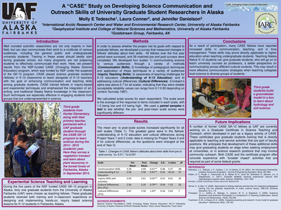
A "CASE" Study on Developing Science Communication and Outreach Skills of University Graduate Student Researchers in Alaska
Molly E. Tedesche, Laura Conner, and Jennifer Danielson
Well rounded scientific researchers are not only experts in their field, but can also communicate their work to a multitude of various audiences, including the general public and undergraduate university students. Training in these areas should ideally start during graduate school, but many programs are not preparing students to effectively communicate their work. Here, we present results from the NSF-funded CASE (Changing Alaska Science Education) program, which was funded by NSF under the auspices of the GK-12 program. CASE placed science graduate students (fellows) in K-12 classrooms to teach alongside of K-12 teachers with the goal of enhancing communication and teaching skills among graduate students. CASE trained fellows in inquiry-based and experiential techniques and emphasized the integration of art, writing, and traditional Alaska Native knowledge in the classroom. Such techniques are especially effective in engaging students from groups that are underrepresented in science.
-

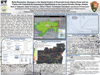
Multi-Resolution Changes in the Spatial Extent of Perennial Arctic Alpine Snow and Ice Fields with Potential Archaeological Significance in the Central Brooks Range, Alaska
Molly E. Tedesche, Adam K. Freeburg, Jeffrey T. Rasic, Christopher Ciancibelli, and Steven R. Fassnacht
Perennial snow and ice fields could be important archaeological and paleoecological resources for Gates of the Arctic National Park and Preserve in the central Brooks Range of Alaska. These features may have cultural significance, as prehistoric artifacts may be frozen within the snow and ice. They also act as important hydrological indicators of climate change within the Park. Globally significant discoveries have been made recently as ancient artifacts and animal dung have been found in melting alpine snow and ice patches in the Southern Yukon (Hare et al. 2004) and Northwest Territories (Meulendyk et al. 2012) in Canada, as well as in the Wrangell mountains in Alaska. The loss of perennial snow and ice coverage in the Brooks Range may yield similar discoveries over time.
-

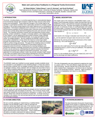
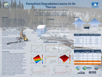
Water and Land-surface Feedbacks in a Polygonal Tundra Environment
W. Robert Bolton, Robert Busey, Larry D. Hinzman, and Scott Peckham
The Arctic, including Alaska, is currently experiencing an unprecedented degree of environmental change with increases in both the mean annual surface temperature and precipitation. These observed changes in the climate regime has resulted in a permafrost condition that is particularly sensitive to changes in both Changes in the surface energy balance and water balances and is susceptible to degradation. Thermokarst topography forms whenever ice-rich permafrost thaws and the ground subsides into the resulting voids. Extensive areas of thermokarst activity are currently being observed throughout the arctic and sub-arctic environments. The important processes involved with thermokarsting include surface ponding, surface subsidence, changes in drainage patterns, and related erosion. In this research, we are applying the land-surface evolution model, ERODE (http://csdms.colorado.edu/wiki/Model:Erode), to an area dominated by low- center, ice-wedge polygons. We are modifying the ERODE model to include land surface subsistence in areas where the maximum active layer depth exceeds the protective layer – the layer of soil above ice-rich soils that acts as a buffer to surface energy processes. The goal of this modeling study is to better understand and quantify the development of thermokarst features in the polygonal tundra environment, emphasizing the resulting feedbacks and connections between hydrologic processes and a dynamic surface topography. Further, we are working on understanding the balance between thermal and mechanical processes with regard to thermokarst processes. This unique application of a landscape evolution model may provide valuable insight related to the rates and spatial extent of thermokarst development and the subsequent hydrologic responses to degrading permafrost in a changing climate.
-

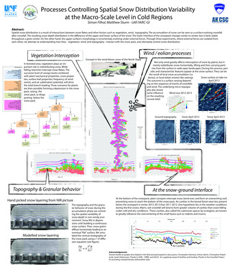
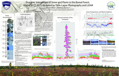
Processes Controlling Spatial Snow Distribution Variability at the Macro-Scale Level in Cold Regions
Simon Filhol and Matthew Sturm
Spatial snow distribution is a result of interactions between snow flakes and other factors such as vegetation, wind , topography. The accumulation of snow can be seen as a surface evolving snowfall after snowfall. The resulting snow depth distribution is the difference of the upper and lower surface of the snow. The lower interface of the snowpack changes winter to winter, but is fairly stable throughout a given winter. On the other hand, the upper surface’s morphology is incrementally evolving under external forces. Through three experiments, where external forces are isolated from each other, we attempt at understanding how they - vegetation, wind, and topography - interact with the snow pack, and ultimately control snow distribution.
-

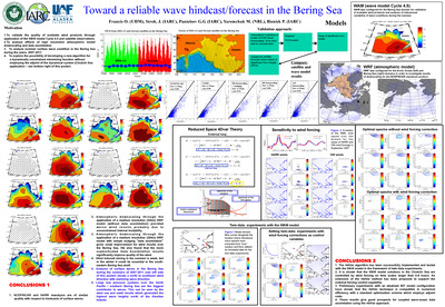
Toward a Reliable Wave Hindcast/Forecast in the Bering Sea
O. Francis, J. Stroh, G. G. Panteleev, M. Yaremchuk, and P. Bieniek
1. To validate the quality of available wind products through application of the WAM model Cycle 4.5 and satellite observations. 2. To analyze effects of high resolution atmospheric model downscaling and data assimilation. 3. To analyze summer surface wave condition in the Bering Sea during the years, 2007-2011. 4. To explore the possibility of developing a new algorithm for a dynamically constrained minimizing function without employing the adjoint of the dynamical system.
-

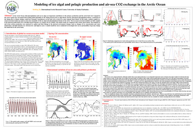
Modeling of Ice Algal and Pelagic Production and Air-Sea CO2 Exchange in the Arctic Ocean
Meibing Jin
In the Arctic Ocean, both phytoplankton and sea ice algae are important contributors to the primary production and the arctic food web. Copepod in the arctic regions have developed their feeding habit depending on the timing between the ice algal bloom and the subsequent phytoplankton bloom. A mismatch of the timing due to climate changes could have dramatic consequences on the food web as shown by some regional observations. In this study, a global coupled ice- ocean-ecosystem model was used to assess the seasonality of the ice algal and phytoplankton blooms in the arctic. The ice-ocean ecosystem modules are fully coupled in the physical model POP-CICE (Parallel Ocean Program- Los Alamos Sea Ice Model). The model results are compared with various observations. The modeled ice and ocean carbon production were analyzed by regions and their linkage to the physical environment changes (such as changes of ice concentration and water temperature, and light intensity etc.) between low- and high-ice years. A model sensitivity run is conducted to investigate how sea ice permeability of gas may change the model bias in the arctic basin.
-
Winter and spring soil CO2 efflux along trans-Alaska pipeline, Alaska
Yongwon Kim
3-year winter and spring soil CO2 efflux was conducted in several sites along the trans-Alaska pipeline, Alaska during winter and spring seasons of 2010 to 2012. During the spring, the snow was disappeared mostly fast in the surrounding of tree such as white spruce (Picea glauca) and black spruce (Picea mariana) in boreal forest of Alaska. On the other hand, in tundra, the snow-covered tussock tundra was firstly exposed due to the topography. In white spruce forest, 4-directional soil CO2 efflux is higher east, south, west, and north in turn. Soil temperature is a crucial role in determining soil CO2 efflux, indicating a exponential curve. The CO2 efflux is related to with and without snow cluster that formed by sublimation. However, the efflux has much lower relation to snow depth. In exposed soil in spring of 2011, the CO2 efflux is similar to the growing season CO2 efflux. 3-yr spring CO2 efflux corresponds to 22-46% of annual CO2 efflux along the trans-Alaska pipeline, Alaska during the spring seasons.
-

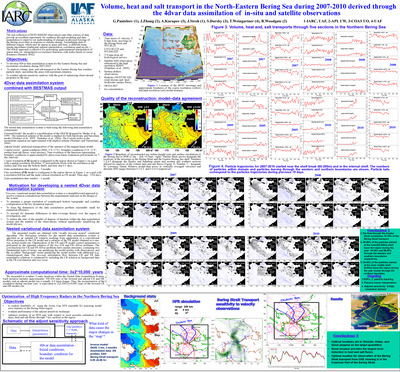
Volume, Heat and Salt Transport in the North-Eastern Bering Sea During 2007-2010 Derived Through the 4dvar Data Assimilation of In-Situ and Satellite Observations
G. G. Panteleev, J. Zhang, A. Kurapov, J. Stroh, S. Dursky, T. Weingartner, and R. Woodgate
The rich collection of BEST-BSIERP observations and other sources of data provide an excellent opportunity for synthesis through modeling and data assimilation to improve our understanding of changes in physical forcings of the Bering ecosystem in response to climate change. Assimilating data of different origins, which may be sparse in space and time, is difficult using simple algorithms (traditional optimal interpolation, correlation analysis etc.). The 4Dvar approach is effective for performing spatiotemporal interpolation of sparse data via interpolation (covariance) functions with scales based on ocean dynamics (Bennett, 2002).
Printing is not supported at the primary Gallery Thumbnail page. Please first navigate to a specific Image before printing.